
Service Information
Tower Mapping
Tower mapping is required to maximize revenues and to identify structural and maintenance concerns.
Every day, tower owners are discovering tenants that they didn’t  know were on their structures or detailed on their tower leasing drawings, primarily through reviews following an accurate mapping of the site. They’re also identifying that some carriers have changed their antenna model and configuration without receiving approval from the site manager. This can also result in an incorrect RF safety assessment. (See RF compliance studies ) know were on their structures or detailed on their tower leasing drawings, primarily through reviews following an accurate mapping of the site. They’re also identifying that some carriers have changed their antenna model and configuration without receiving approval from the site manager. This can also result in an incorrect RF safety assessment. (See RF compliance studies )
An accurate tower mapping is the glue that holds the tower and its revenue stream together. Without it, owners cannot obtain an analysis to identify whether the structure can accommodate another tenant or if the tower is presently overloaded. Some mapping requirements will entail identifying all leg and member sizes in addition to the antennas, mounts, lines and other attachments supported by the structure as well as sweep testing if they are a carrier owner. Other requests will just require an 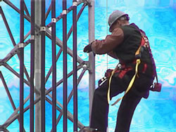 inventory of tenant equipment when assembly and design drawings are available. inventory of tenant equipment when assembly and design drawings are available.
Over the years, all tower owners have experienced some less than accurate mappings from companies that did not have the organizational skills and software to assemble the information correctly or they did not have qualified employees capable of accurately inputting the data.
Converting hand-written notes into final reports days later stretches a mapping’s accuracy. A precise inventory can only be obtained if the information is immediately entered into a software program while on site. Some contractors will provide the obtained data to their clients in a relational database that allows the tower owner to customize reports with an internet-based access display. the information is immediately entered into a software program while on site. Some contractors will provide the obtained data to their clients in a relational database that allows the tower owner to customize reports with an internet-based access display.
Additional capabilities of some software will allow the owner to maintain a historical profile of the site including maintenance issues, photographs and other site information. Software can be purchased for site mapping. To be compliant with OSHA standards, a second employee must be on site at all times whenever elevated mappings on towers are being performed.
 Missing design drawings coupled with folded tower manufacturers are requiring tower owners to obtain a detailed audit of the structure and tenant equipment to identify its current capacity. Local mappings can range from $900 for field verification of design drawings along with a detailed equipment loading profile and photographs (up to a 250’ self supporting tower), to $2,200 for a similar structure requiring detailed as-built drawings and photographic documentation. Nondestructive Missing design drawings coupled with folded tower manufacturers are requiring tower owners to obtain a detailed audit of the structure and tenant equipment to identify its current capacity. Local mappings can range from $900 for field verification of design drawings along with a detailed equipment loading profile and photographs (up to a 250’ self supporting tower), to $2,200 for a similar structure requiring detailed as-built drawings and photographic documentation. Nondestructive 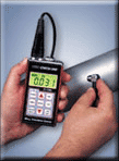 identification requirements are additional. Most mapping pricing is based upon the client-specific requirements and will be influenced by the number of sites awarded. identification requirements are additional. Most mapping pricing is based upon the client-specific requirements and will be influenced by the number of sites awarded.
Ultrasonic wall thickness gauges are often required to identify structures where design drawings are not available. They range in price from $1,000 for a basic model with no data logging capabilities to $1,600 for a unit that will provide data logging and allow you to identify a thickness minus the painted surface. This is helpful since many earlier installed structures have had multiple coats of paint applied over the years. If you are in a high RF environment, identify if the unit will perform properly. Some test equipment rental companies will provide one for $185 per week.
We recommend that you contact our mapping professionals to obtain additional information about their services, capabilities and experience.
|