


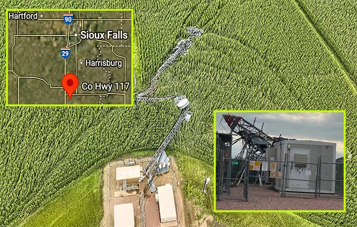
This 275-foot guyed tower near Beresford, South Dakota, was no match for the straight-line winds exceeding 90 mph that tore through Lincoln County on Monday night. The multi-carrier structure, which supported antennas for AT&T, Verizon, and T-Mobile, collapsed during the powerful storm, severing rural connectivity. (Photos: Lincoln County Sheriff’s Office)
Winds exceeding 90 miles per hour swept through Lincoln County, South Dakota, on Monday night, leaving a trail of destruction in their wake.
The intense storm, described by emergency officials as containing straight-line winds potentially stronger than some tornadoes, uprooted trees, flattened barns, tore the roofs off buildings, and toppled a 275-foot cell tower located off of 29140 County Highway 117, near Beresford, about 35 miles south of Sioux Falls.

Widespread damage was reported in Lincoln County when the storm tore off roofs and caused other severe damage to businesses and homes. Fortunately, no fatalities or serious injuries were reported. (Photo: Lincoln County Sheriff’s Office)
The multi-carrier guyed tower is owned by SBA Communications and was constructed in 1973 under ANSI/EIA RS-222-C, when the applicable design was an 115 mph ultimate wind speed, using the fastest-mile technology, the standard used at that time.
The Lincoln County Sheriff’s Office and emergency management teams based their 90 mph wind estimate on widespread structural damage observed throughout rural parts of the county, particularly near Hudson.
While nearby weather stations recorded gusts in the 65–70 mph range, localized wind bursts—often stronger and more damaging—accounted for the severe destruction that has since prompted cleanup of the guyed tower and the placement of a temporary cell site.
