Service Information
Surveyors
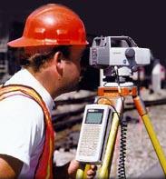
Before the architect can provide submittal drawings for the zoning authority for a raw land site, the professional services of a registered surveyor are required. The same information is included in the drawings prepared by the architect for submittal for a building permit.
Surveying services include topographic and boundary surveys, property line surveys and descriptions, establishing control points, and the preparation of site plans reflecting the location of facilities and the identified parcel. Other services that may be required are:
- Colocation Tower Site Surveys
- FAA/FCC Geographic coordinate reports: 1-A Certification, 2C Certification
- GIS / GPS Surveys
- Site Surveys
- Roof Top Communication Surveys
- Fiber Optic Installation Site Surveys
- Tower As-Built Surveys
- Construction Stake Out
- Legal Descriptions and Easements
Final survey drawings must be stamped by the surveyor or civil engineer licensed in the state where the work is located. Clients are typically requesting completed surveys, survey certificates and legal descriptions within two weeks after the notice to proceed.
Although anchors and base locations for towers are usually staked at their construction point, the survey stakes and points set during the process of most construction surveying are not typically set at the actual construction point, but usually on some sort of offset. This is done so that the survey stake is not disturbed by excavation or other activities that will take place at the actual point of construction. The stakes are marked with an "offset" and a "grade", which provides the construction crew with the spacial relationship of the construction stake to the actual point of construction. The distance of the offset should be coordinated with the contractor to accomodate any specific needs due to existing field conditions or special equipment, and should be clearly marked on the survey stake (usually by a number enclosed in a circle). The "grade" represents the change in elevation that needs to be obtained from the reference point to the actual construction point, expressed as a "cut" (lower in elevation) or a "fill" (higher in elevation). The grade should also indicate the vertical feature that the grade is referencing, usually a finished floor elevation. is done so that the survey stake is not disturbed by excavation or other activities that will take place at the actual point of construction. The stakes are marked with an "offset" and a "grade", which provides the construction crew with the spacial relationship of the construction stake to the actual point of construction. The distance of the offset should be coordinated with the contractor to accomodate any specific needs due to existing field conditions or special equipment, and should be clearly marked on the survey stake (usually by a number enclosed in a circle). The "grade" represents the change in elevation that needs to be obtained from the reference point to the actual construction point, expressed as a "cut" (lower in elevation) or a "fill" (higher in elevation). The grade should also indicate the vertical feature that the grade is referencing, usually a finished floor elevation.
A limited boundary survey with a topo and 2C letter averages $4,000 with an access road up to 1,000'. Construction staking can be budgeted at $1,200 and an as-built survey at $1,700. Construction staking can be budgeted at $1,200 and an as-built survey at $1,700.
We recommend that you contact our listed licensed surveyors to obtain additional information about their services, capabilities and experience.
GPS provides pinpoint accuracy
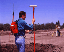
In addition to the standard equipment required for professional surveying, many surveyors are armed with Global Positioning  System (GPS) receivers, laptop computers, portable printers and software systems to allow for on-site reduction of state plane coordinates, longitudes, latitudes, elevations and true North bearings. With a GPS device, positions on the earth's surface can be quickly and accurately located by measuring distances to orbiting satellites. This is done by determining the time required for radio signals broadcast by the satellites to travel to the points in question. Once the positions of the various points (in coordinates or latitudes and longitudes) are determined, the distances between them can easily be computed with accuracies that can exceed 1/1,000,000. System (GPS) receivers, laptop computers, portable printers and software systems to allow for on-site reduction of state plane coordinates, longitudes, latitudes, elevations and true North bearings. With a GPS device, positions on the earth's surface can be quickly and accurately located by measuring distances to orbiting satellites. This is done by determining the time required for radio signals broadcast by the satellites to travel to the points in question. Once the positions of the various points (in coordinates or latitudes and longitudes) are determined, the distances between them can easily be computed with accuracies that can exceed 1/1,000,000.
Typical owner requests for an as-built survey include:
- Top of tower foundation(s)
- Top of tower steel
- Top and bottom of antennas at all elevations
- Top of lightning rod
- Top of hazard light
- Elevation of all concrete pads
- Locate corners of concrete pads
- Locate compound fence corners
- All improvements, encumbrances and visible obstructions
- Centerline of access road from site gate to public right-of-way
- Verify lease boundaries and re-pin as necessary
- Verify location of tower center
|